Eritrea ⇄  Compare
Country Profile

Eritrea flag Eritrea

Eritrea, officially the State of Eritrea, is a country in the Horn of Africa region of East Africa.
ISO ERI · ER  ·  Region Africa  ·  Figures for 2024

Key Statistics

World Bank · 2024

Geography & Terrain


Satellite · Mapbox
Physical terrain of Eritrea.
Political · Mapbox
Political boundaries, neighbours and principal cities.
View the Eritrea population-density map →

Health System


Health Outcomes
25.5
per 1,000 live births
291.0
per 100,000 live births
Spending & Access
System Capacity
0.1
per 1,000 people
1.5
per 1,000 people
1.0
per 1,000 people
Preventive Care
95.0%
children 12–23 mo.
93.0%
children 12–23 mo.
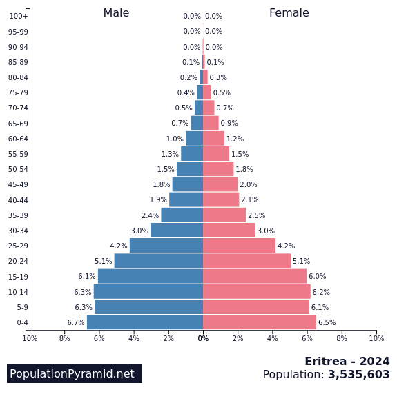
Age Structure
Distribution by age and sex, 2024.Source: PopulationPyramid.net

Economy


GDP composition by sector.Source: World Bank
Trade balance, % of GDP.Source: World Bank
Composition of goods exports, 2022.Source: OEC
Composition of goods imports, 2022.Source: OEC

Education


Society & Equality


Technology & Infrastructure


Historical Trends


Population, 1960–2024.
Gross domestic product, US$.
Life expectancy at birth.

About Eritrea


Eritrea, officially the State of Eritrea, is a country in the Horn of Africa region of East Africa. Its capital and largest city is Asmara. The country is bordered by Ethiopia to the south, Sudan to the west, and Djibouti to the southeast. The northeastern and eastern parts of Eritrea have an extensive coastline along the Red Sea. The country has a total area of approximately 117,600 km2 (45,406 sq mi), and includes the Dahlak Archipelago and several of the Hanish Islands.

Source: Wikipedia

Detailed Map


Cities, roads and terrain of Eritrea.Source: Geoapify · OSM

Population Density


Modelled population density, by 1 km cell.Source: WorldPop
View the detailed population density page for Eritrea →