Indonesia ⇄  Compare
Country Profile

Indonesia flag Indonesia

Indonesia, officially the Republic of Indonesia, is a country in Southeast Asia and Oceania, between the Indian and Pacific oceans.
ISO IDN · ID  ·  Region Asia  ·  Figures for 2024

Key Statistics

World Bank · 2024

Geography & Terrain


Satellite · Mapbox
Physical terrain of Indonesia.
Political · Mapbox
Political boundaries, neighbours and principal cities.
View the Indonesia population-density map →

Health System


Health Outcomes
17.0
per 1,000 live births
140.0
per 100,000 live births
Spending & Access
System Capacity
0.5
per 1,000 people
3.2
per 1,000 people
1.4
per 1,000 people
Preventive Care
78.0%
children 12–23 mo.
85.0%
children 12–23 mo.
Age Structure
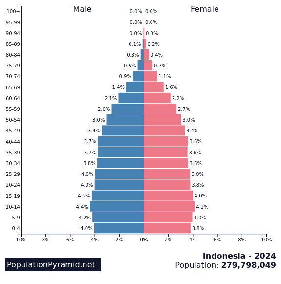
Distribution by age and sex, 2024.Source: PopulationPyramid.net

Economy


GDP composition by sector.Source: World Bank
Trade balance, % of GDP.Source: World Bank
Composition of goods exports, 2022.Source: OEC
Composition of goods imports, 2022.Source: OEC

Education


Society & Equality


Technology & Infrastructure


Historical Trends


Population, 1960–2024.
Gross domestic product, US$.
Life expectancy at birth.

About Indonesia


Indonesia, officially the Republic of Indonesia, is a country in Southeast Asia and Oceania, between the Indian and Pacific oceans. Comprising over 17,000 islands, including Sumatra, Java, Sulawesi, and parts of Borneo and New Guinea, Indonesia is the world's largest archipelagic state and the 14th-largest country by area, at 1,904,569 square kilometres. Indonesia has significant areas of wilderness that support one of the world's highest levels of biodiversity. It shares land borders with Papua New Guinea, Timor-Leste, and East Malaysia, as well as maritime borders with Australia, Singapore, the Philippines and others.

Source: Wikipedia

Detailed Map


Cities, roads and terrain of Indonesia.Source: Geoapify · OSM

Population Density


Modelled population density, by 1 km cell.Source: WorldPop
View the detailed population density page for Indonesia →