Israel ⇄  Compare
Country Profile

Israel flag Israel

Israel, officially the State of Israel, is a country in the Southern Levant region of West Asia.
ISO ISR · IL  ·  Region Asia  ·  Figures for 2024

Key Statistics

World Bank · 2024

Geography & Terrain


Satellite · Mapbox
Physical terrain of Israel.
Political · Mapbox
Political boundaries, neighbours and principal cities.
View the Israel population-density map →

Health System


Health Outcomes
2.7
per 1,000 live births
2.0
per 100,000 live births
Spending & Access
System Capacity
3.8
per 1,000 people
5.9
per 1,000 people
3.1
per 1,000 people
Preventive Care
98.0%
children 12–23 mo.
98.0%
children 12–23 mo.
Age Structure
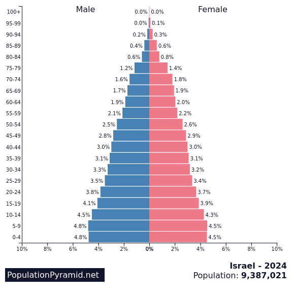
Distribution by age and sex, 2024.Source: PopulationPyramid.net

Economy


GDP composition by sector.Source: World Bank
Trade balance, % of GDP.Source: World Bank
Composition of goods exports, 2022.Source: OEC
Composition of goods imports, 2022.Source: OEC

Education


Society & Equality


Technology & Infrastructure


Historical Trends


Population, 1960–2024.
Gross domestic product, US$.
Life expectancy at birth.

About Israel


Israel, officially the State of Israel, is a country in the Southern Levant region of West Asia. It is bordered by Lebanon to the north, Syria to the northeast, Jordan to the east, and Egypt to the southwest. Israel occupies the West Bank and the Gaza Strip of the Palestinian territories, as well as the Syrian Golan Heights. Israel's western coast lies on the Mediterranean Sea, its southern tip reaching the Red Sea, and the east includes the Earth's lowest point near the Dead Sea. Jerusalem is the government seat and proclaimed capital, while Tel Aviv is Israel's largest urban area and economic centre.

Source: Wikipedia

Detailed Map


Cities, roads and terrain of Israel.Source: Geoapify · OSM

Population Density


Modelled population density, by 1 km cell.Source: WorldPop
View the detailed population density page for Israel →