Mali ⇄  Compare
Country Profile

Mali flag Mali

Mali, officially the Republic of Mali, is a landlocked country in West Africa.
ISO MLI · ML  ·  Region Africa  ·  Figures for 2024

Key Statistics

World Bank · 2024

Geography & Terrain


Satellite · Mapbox
Physical terrain of Mali.
Political · Mapbox
Political boundaries, neighbours and principal cities.
View the Mali population-density map →

Health System


Health Outcomes
57.6
per 1,000 live births
367.0
per 100,000 live births
Spending & Access
System Capacity
0.2
per 1,000 people
0.3
per 1,000 people
0.2
per 1,000 people
Preventive Care
82.0%
children 12–23 mo.
72.0%
children 12–23 mo.
Age Structure
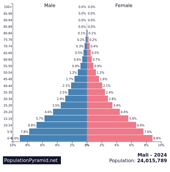
Distribution by age and sex, 2024.Source: PopulationPyramid.net

Economy


GDP composition by sector.Source: World Bank
Trade balance, % of GDP.Source: World Bank
Composition of goods exports, 2022.Source: OEC
Composition of goods imports, 2022.Source: OEC

Education


Society & Equality


Technology & Infrastructure


Historical Trends


Population, 1960–2024.
Gross domestic product, US$.
Life expectancy at birth.

About Mali


Mali, officially the Republic of Mali, is a landlocked country in West Africa. It is the eighth-largest country in Africa and the 23rd largest country in the world, with an area of over 1,240,192 square kilometres (478,841 sq mi). The country is bordered to the north by Algeria, to the east by Niger, to the northwest by Mauritania, to the south by Burkina Faso and Ivory Coast, and to the west by Guinea and Senegal. The population of Mali is about 23.29 million, 47.19% of which are estimated to be under the age of 15 in 2024. Its capital and largest city is Bamako. The country has 13 official languages, of which Bambara is the most commonly spoken.

Source: Wikipedia

Detailed Map


Cities, roads and terrain of Mali.Source: Geoapify · OSM

Population Density


Modelled population density, by 1 km cell.Source: WorldPop
View the detailed population density page for Mali →