Belgium ⇄  Compare
Country Profile

Belgium flag Belgium

Belgium, officially the Kingdom of Belgium, is a country in Northwestern Europe.
ISO BEL · BE  ·  Region Europe  ·  Figures for 2024

Key Statistics

World Bank · 2024

Geography & Terrain


Satellite · Mapbox
Physical terrain of Belgium.
Political · Mapbox
Political boundaries, neighbours and principal cities.
View the Belgium population-density map →

Health System


Health Outcomes
3.0
per 1,000 live births
4.0
per 100,000 live births
Spending & Access
System Capacity
3.6
per 1,000 people
12.9
per 1,000 people
5.4
per 1,000 people
Preventive Care
97.0%
children 12–23 mo.
96.0%
children 12–23 mo.
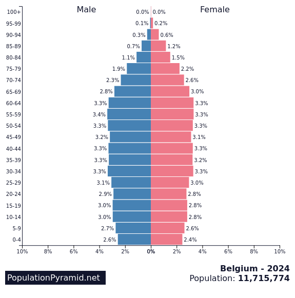
Age Structure
Distribution by age and sex, 2024.Source: PopulationPyramid.net

Economy


GDP composition by sector.Source: World Bank
Trade balance, % of GDP.Source: World Bank
Composition of goods exports, 2022.Source: OEC
Composition of goods imports, 2022.Source: OEC

Education


Society & Equality


Technology & Infrastructure


Historical Trends


Population, 1960–2024.
Gross domestic product, US$.
Life expectancy at birth.

About Belgium


Belgium, officially the Kingdom of Belgium, is a country in Northwestern Europe. Situated in a coastal lowland region known as the Low Countries, it is bordered by the Netherlands to the north, Germany to the east, Luxembourg to the southeast, France to the south, and the North Sea to the west. Belgium covers an area of 30,689 km2 (11,849 sq mi) and has a population of more than 11.8 million; its population density of 383/km2 (990/sq mi) ranks 22nd in the world and sixth in Europe. The capital and largest metropolitan region is Brussels; other major cities are Antwerp, Ghent, Charleroi, Liège, Bruges, Namur, and Leuven.

Source: Wikipedia

Detailed Map


Cities, roads and terrain of Belgium.Source: Geoapify · OSM

Population Density


Modelled population density, by 1 km cell.Source: WorldPop
View the detailed population density page for Belgium →